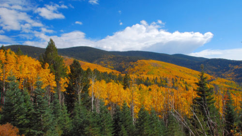
Did you know that as part of the forest planning process the Carson National Forest is seeking to downgrade the Wild and Scenic eligibility protections for over 60 rivers throughout northern New Mexico? Downgrading these rivers will make it easier for timber harvesting, mining, road development, dams, and other development in these rivers and along the river corridors. These downgrades and the lack of management along these rivers could have significant impacts to the area’s wildlife, fisheries, outdoor recreation, and cultural values.
Throughout the process the Carson has decided that hunting, hiking, and camping are no longer outstanding recreational values. Despite the amazing Big Horn Sheep populations, and unique grounds for elk calving, the Carson apparently no longer believes that these areas are outstandingly remarkable wildlife values.
Rather than hold open meetings and workshops to discuss these major changes with the public, the Carson has only given the public the option to provide written comments about these major changes.
While we are working to address many of these concerns, the New Mexico Wildlife Federation would also like to encourage you to comment on protecting these rivers for their recreational, cultural, historical, scenic and wildlife values. On the eve of the 50th anniversary of the Wild and Scenic Rivers Act, it is critical that you voice your concerns to protect the last remaining free-flowing rivers on our national forests and their outstandingly remarkable values.
Comments are due by November 15th, 2017.
- Please submit comments via email to: carsonplan@fs.fed.us
- Please submit written comments to:
- Carson National Forest
- Attn: Plan Revision—Wild and Scenic Rivers
- 208 Cruz Alta Road
- Taos, NM 87571
Below are some suggested talking points to include in your comments:
- The Carson should keep in line with national guidelines which state that hunting, hiking, and camping should be included in the definition for Outstandingly Remarkable Values, and that these activities are inline with New Mexico’s culture and values.
- The region of comparison for wildlife values is too large, and should be reduced in size to include northern New Mexico and southern Colorado and not the entire Four Corners region.
- The Carson should be holding open public meetings to talk about how these proposed downgrades which will impact you, your children, your community, our state’s wildlife, and the health of the forest.
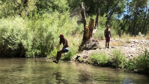
- Note some of your favorite fishing, camping, hunting, and hiking spots on the threatened rivers.
- Include why the rivers below are important to you or community from a cultural or historical perspective.
Read the draft assessment on the Carson National Forest website.
LIST OF RIVERS GOING FROM ELIGIBLE TO INELIGIBLE (61 river segments):
Camino Real:
Agua Piedra Creek
Rio de Las Trampas
Rio de Las Trampas – headwaters
Rio San Leonardo
Rio Grande del Rancho (from headwaters to Rito de la Olla)
Canon Tio Maes
Gallegos Canyon
Flechado Canyon
La Cueva Canyon
Rio Santa Barbara (From campground down to FR 116 bridge)
Rio Santa Barbara (from FR116 to Forest boundary)
Rito de la Olla
Rito de la Presa
Arellano Canyon
Tierra Amarillo Canyon
Aqua Caliente Canyon
Duran Creek
Questa Ranger District:
Bitter Creek
Cabresto Creek
Columbine Creek (from Deer Creek to Red River)
Gold Creek
Jiron Canyon
McCrystal Creek
Middle Ponil (3 segments)
North Ponil Creek
Pioneer Crekk
Red River (Goose Creek to Hwy 522)
Red River (Hwy 522 down to already designated segment)
West Fork Red River
Gavilan Canyon
South Fork Rio Hondo
Yerba Canyon
Long Canyon
San Cristobal
Rito del Medio
Tres Piedras
Osier For Rio Brazos
East Fork Rio Brazos
Osier Creek
Beaver Creek
Diablo Creek (headwaters to Beaver Creek)
Rio San Antonio (from Stewart Meadows to Forest Boundary)
Rio San Antonio (from Rio Nutrias to Stewart Meadows)
Tanques Canyon
Rio Nutrias
Canada Tio Grande
Rio Tusas (from section 16 tank to private land)
Rio Tusas Box (from Spring Creek to Las Tablas)
Rio Vallecitos (from forest boundary to private land – above Placer creek)
Placer Creek (from Hopewell Lake To Rio Vallecitos)
El Rito
Salvador Canyon
El Rito Creek
Rio Chama (1 mile segment of FS land between Abiquiu Dam and El Rito Creek)
Arroyo de Comales
Arroyo del Cobre
Arroyo Blanco
Jicarilla
Bancos Canyon
Cabresto Canyon
Vaqueros Canyon
Canjilon
Canjilon Creek (from private land boundary below canjilon to private land near martinez canyon).